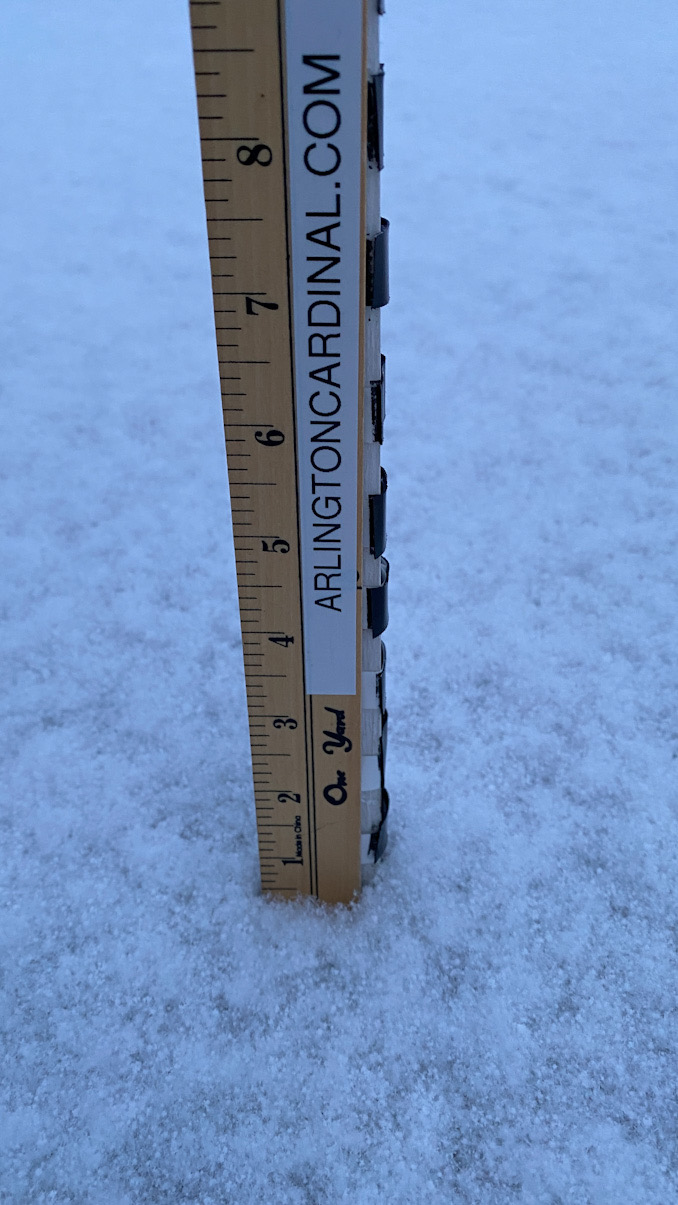
Only 0.5 inch of light, fluffy snow has accumulated in Arlington Heights as of 7:15 a.m. Heavier snow has fallen in a line from Glencoe to Evanston to O’Hare International Airport to around Midway International Airport where some areas may see 6 to 10 inches. Forecasted snow accumulation for Arlington Heights has fluctuated wildly overnight. Currently the total snow accumulation forecast for Arlington Heights is 2 inches. At one point the Arlington Heights snow accumulation forecast was 5 inches as the Lake Effect Snow band wiggled around the Chicago metro area, but the Lake Effect Snow band marking the highest rate of snowfall stayed east of Arlington Heights. Glencoe, Winnetka, Highland Park, Norridge, Park Ridge and southwest may be hardest hit by the Lake Effect Snow band.
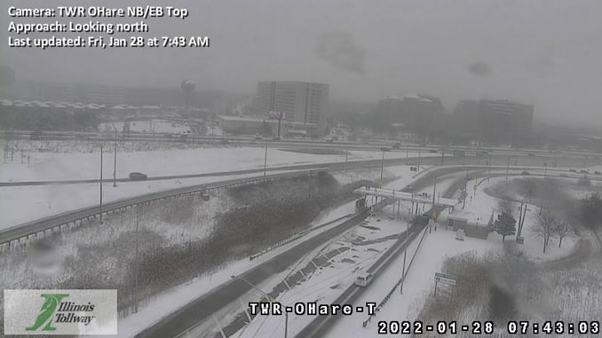
The intense Lake Effect Snow (LES) band continues at 7:00 a.m. and took residence recently stretching from Glencoe to Norridge, Oak Park, Palos Hills, and Homer Glen. Snow rates in the most intense parts have been reported to range from 2 to 2.5″/hr with 5″ accumulation 3 miles SW of Midway Airport since 1:30 a.m. Friday morning. In addition, NWS Chicago has received reports of treacherous travel conditions along area interstates intersecting the snowband, including several car accidents on Interstate 55 alone. While the LES band has shift northwest over the past few hours (and is no longer impacting downtown Chicago), there are signs it is beginning to stall. Accordingly, have cautiously increased snow totals in our gridded database along a narrow axis in the 6-10″ range with the highest totals in northeastern Cook county. Regardless of snow amounts, conditions under the band will remain dangerous and any commuters underneath will be all but crawling.
The snow showers away from the band along and south of I-80 are also worth a mention with AWOS/ASOS visibilities reporting low visibility. A quick coating (an inch or two) appears possible through the morning hours, which may lead to slick spots. The bottom line is to take it slow this morning and to prepare for rapidly changing conditions, especially if heading into Cook county.
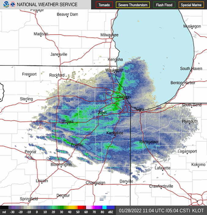
Weather Radar shows the Lake Effect Snow band moving northeast to southwest from the Lake-Cook border at the shoreline of Lake Michigan southwest over O’Hare International to Wheaton and Lombard and Naperville.
See also Arlingtoncardinal.com/clouds
Difficult driving conditions continue especially in the red shaded area due to lake effect snow. Prepare for long commutes this morning as snow piles up. The snow is expected to gradually taper this afternoon. #ilwx #inwx pic.twitter.com/i7khryKJVX
— NWS Chicago (@NWSChicago) January 28, 2022
⚠️4:15 AM CST: An intense lake effect snow band will continue this morning across the Chicago area. Prepare for significant (1+ hour) travel delays with low visibility and snow-covered roads, especially in Cook county. #ilwx pic.twitter.com/eCAknbl2t7
— NWS Chicago (@NWSChicago) January 28, 2022
Winter Storm Warning URGENT – WINTER WEATHER MESSAGE National Weather Service Chicago IL 342 AM CST Fri Jan 28 2022
ILZ006-103-104-281745- /O.CON.KLOT.WS.W.0002.000000T0000Z-220128T1800Z/ Lake IL-Northern Cook-Central Cook- Including the cities of Waukegan, Buffalo Grove, Mundelein, Gurnee, Evanston, Des Plaines, Schaumburg, Palatine, Northbrook, Chicago, Cicero, Oak Lawn, Oak Park, and La Grange 342 AM CST Fri Jan 28 2022
…WINTER STORM WARNING REMAINS IN EFFECT UNTIL NOON CST TODAY…
* WHAT…Dangerous travel conditions and intense lake effect snow expected. Snowfall rates of 1 to 2 inches per hour will lead to total snow accumulations of 4 and 8 inches especially over southeastern Lake and northern Cook counties. Locally higher totals are possible. Western portions of Lake County Illinois and far western portions of northern Cook County could end u P with less than an inch of accumulation.
* WHERE…Lake IL and Northern Cook Counties.
* WHEN…Through noon today.
* IMPACTS…Conditions will be highly variable, potentially going from just flurries to near white out conditions in heavy snow over just a few mile stretch. Under the intense snow band, travel will be extremely difficult including during the height of this mornings commute.
* ADDITIONAL DETAILS…If travel cannot be postponed, plan for significantly longer travel times in areas impacted by the most intense snowfall.
PRECAUTIONARY/PREPAREDNESS ACTIONS…
If you must travel, keep an extra flashlight, food, and water in your vehicle in case of an emergency.
The latest road conditions for Illinois can be obtained on the internet at www.gettingaroundillinois.com.
O’HARE FORECAST …
Today: Snow showers, mainly before 3pm. The snow could be heavy at times. High near 20. North northwest wind around 5 mph, with gusts as high as 10 mph. Chance of precipitation is 100%. Total daytime snow accumulation of 2 to 4 inches possible.
Tonight: Mostly clear, with a low around 1. Wind chill values as low as -9. Northwest wind around 5 mph, with gusts as high as 10 mph.
Saturday: Increasing clouds, with a high near 22. Wind chill values as low as -9. West southwest wind 5 to 10 mph becoming south in the afternoon.
Saturday Night: Mostly cloudy, with a low around 17. South wind 5 to 10 mph becoming west northwest after midnight.
Sunday: Partly sunny, with a high near 28. Northwest wind 5 to 10 mph, with gusts as high as 15 mph.
Sunday Night: Mostly cloudy, with a low around 14.
Monday: Partly sunny, with a high near 34.
Monday Night: Mostly cloudy, with a low around 31.
Tuesday: A chance of rain and snow before 9am, then a chance of rain. Cloudy, with a high near 41.
Tuesday Night: A slight chance of rain and snow before 9pm, then a chance of snow. Cloudy, with a low around 25.
Wednesday: Snow likely. Mostly cloudy, with a high near 30.
Wednesday Night: Snow likely. Mostly cloudy, with a low around 17.
Thursday: A chance of snow. Mostly cloudy, with a high near 24.
LAKE TEMPS …
SOUTHERN LAKE MICHIGAN WATER TEMPERATURES
NATIONAL WEATHER SERVICE CHICAGO/ROMEOVILLE IL
909 AM CST Thu Jan 27 2022
LAKE MICHIGAN WATER TEMPERATURES…
CHICAGO SHORE………33.
CHICAGO CRIB……….34.
MICHIGAN CITY……….33.
&&
M IS FOR MISSING DATA THAT IS NORMALLY AVAILABLE.
THE MICHIGAN CITY WATER TEMPERATURE SENSOR IS LOCATED AT A WATER
INTAKE ONE MILE OFFSHORE AND 60 FEET BELOW WATER SURFACE. IT IS READ
EVERY DAY OF THE YEAR.
january.chicagoweatherstation.com
Chicago Weather Forecast for your MAC/PC/TABLET includes surrounding suburbs.
^^ MOBILE? USE VOICE MIC ^^
facebook …
Please ‘LIKE’ the ‘Arlington Cardinal Page. See all of The Cardinal Facebook fan pages at Arlingtoncardinal.com/about/facebook …
Help fund The Cardinal Arlingtoncardinal.com/sponsor
20240105-1435future
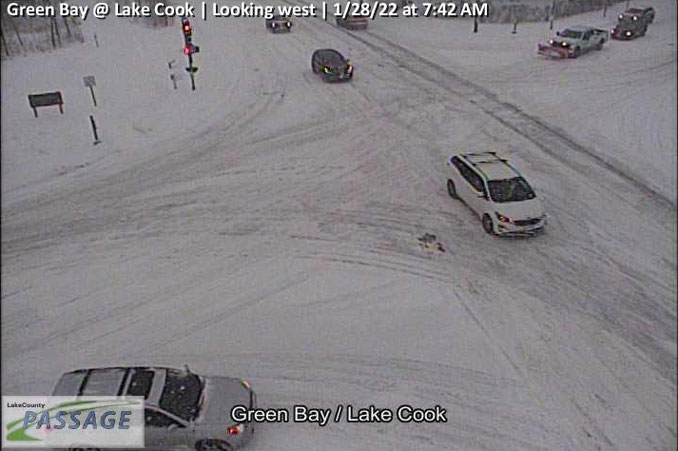
and Green Bay Road Jan. 28, 2022 at 7:42AM CST (SOURCE: Lake County PASSAGE).