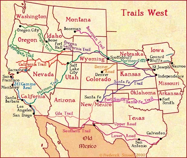
Early Western Migration Trails
(Source: reddit.com)
Related Posts

![People were asked to divide the United States into exactly five general regions
[[MORE]] atrubetskoy:
“ This map shows how Americans see the United States divided into five regions. It shows the average of a total 612 responses to the question,
“If...](https://64.media.tumblr.com/422b08773ad0af5c38fd89e3f16a4f71/tumblr_n4ebitmJkX1rasnq9o1_100.png)
![Population Density of Contiguous United States by Census Block.
[[MORE]]Data source: https://www.census.gov/geo/maps-data/data/tiger-data.html, QGIS
This is literally the lowest geographical area the United States has. There are around 8.3 million...](https://64.media.tumblr.com/27730c938ca01780f146568a533be80a/tumblr_nmprlroOWu1rasnq9o1_100.png)
![Transportation in the United States - Roads, Railroads and Ferry routes.
[[MORE]]Source: Reviving the Statistical Atlas of the United States with New Data a very interesting project using new data to create old-style atlas maps using only public...](https://64.media.tumblr.com/422f65e4eaa861442cc23f800e209a52/tumblr_nqtx0odpMA1rasnq9o1_100.jpg)


 pk-17 liked this
  20204u reblogged this from cynicalgeezerspectator 20204u liked this
  thefandomlesbian liked this
  scurvyeunuch reblogged this from mapsontheweb
  timmyberes liked this
  differentvoiddreamer liked this cynicalgeezerspectator reblogged this from lowcountrytohighprairie and added:
 a nice reference…traveled someof them….
 sastrugie reblogged this from mapsontheweb
  themightyfoo said:
This is missing the Chisolm Trail in Texas, Oklahoma and Kansas
themightyfoo said:
This is missing the Chisolm Trail in Texas, Oklahoma and Kansas  breecoleur liked this
  nebris reblogged this from mapsontheweb nebris liked this
  scapegrace74-blog liked this
  kicsibilly reblogged this from mapsontheweb kicsibilly liked this
  dis0rderly liked this
  ghostbee-23 liked this
  sunshadows88 liked this
  qdjfc5 liked this 5peedracer liked this
  draenar liked this