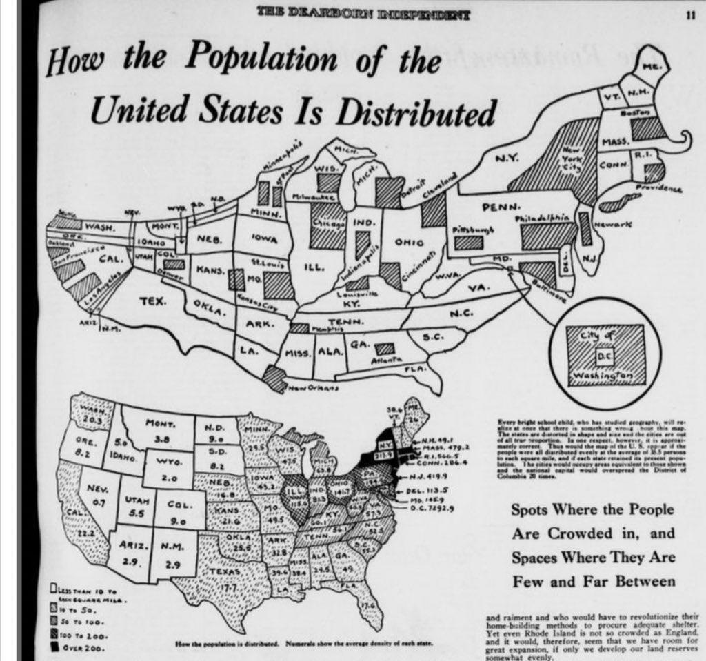
100 years ago,
on April 10, 1921 population distribution in the United States with sizes of states adjusted for population, and sizes of cities adjusted for how much of the population of the state they comprise.
(Source: reddit.com)
Related Posts


![Map showing the African American population distribution in the United States, 1900.
[[MORE]]From W. E. B. Du Bois’s Mind-Expanding Depictions of Black Life In 1900.](https://64.media.tumblr.com/eb6498b5a980572d26ffa951978ae3f7/tumblr_ovn4cer45o1rasnq9o1_100.jpg)
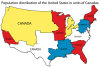
![The USA with state borders redrawn with an even population distribution
[[MORE]]
“ This Electoral Reform Map redivides the territory of the United States into 50 bodies of equal size - 281,421,906 divided by 50 is 5,616,997. This map shows one...](https://64.media.tumblr.com/ed06213fb2a824fef0fc9fc293f7096f/tumblr_nblmbmb1xK1rasnq9o1_100.jpg)


100 years ago,
on April 10, 1921 population distribution in the United States with sizes of states adjusted for population, and sizes of cities adjusted for how much of the population of the state they comprise.
(Source: reddit.com)
 davvero-annoiatx liked this
  briefly-noted reblogged this from mapsontheweb
  chaplinfortheages liked this
  eldritchcorvidae liked this
  spiltcandycoatedpunkblood liked this
  bellafuga reblogged this from mythologicalmango
  wgfiction-on-deviantart liked this fatjack03 liked this
  nosgothic liked this
  fishmech reblogged this from reidio-silence
  whooliganshenanigans reblogged this from sprintingbear
  ssoapss liked this
  thiinka liked this
  seoul-food liked this
  cts-tj1 liked this tco66 reblogged this from mapsontheweb tco66 liked this
  sparkles530 liked this blkguy408 liked this
  iprfan liked this italsir liked this
  theladyparasimtamol liked this
  austinwashere liked this
  princess-cinnie reblogged this from sugoiney-weaver
  caseopencaseshut liked this
  riftar liked this
  mobiustheoryy reblogged this from mapsontheweb
  dogpawsswapgod liked this