
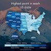
Highest point in each US state.
Related Posts
![Highest Points of US States.
[[MORE]] u/rbsanford :
All the highest points:
• Alabama: Cheaha Mountain (2413’) [Prominence: 1445’]
• Alaska: Mt. McKinley (20,310’) [20,146’]
• Arizona: Humphreys Peak (12,637’) [6039’]
• Arkansas: Mt. Magazine (2753’)...](https://64.media.tumblr.com/aba720d0a79e0cc9204978bcc3712cf9/tumblr_pc2scqhMwz1rasnq9o1_100.png)

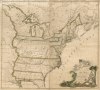
![People were asked to divide the United States into exactly five general regions
[[MORE]] atrubetskoy:
“ This map shows how Americans see the United States divided into five regions. It shows the average of a total 612 responses to the question,
“If...](https://64.media.tumblr.com/422b08773ad0af5c38fd89e3f16a4f71/tumblr_n4ebitmJkX1rasnq9o1_100.png)
![Transportation in the United States - Roads, Railroads and Ferry routes.
[[MORE]]Source: Reviving the Statistical Atlas of the United States with New Data a very interesting project using new data to create old-style atlas maps using only public...](https://64.media.tumblr.com/422f65e4eaa861442cc23f800e209a52/tumblr_nqtx0odpMA1rasnq9o1_100.jpg)
![Population Density of Contiguous United States by Census Block.
[[MORE]]Data source: https://www.census.gov/geo/maps-data/data/tiger-data.html, QGIS
This is literally the lowest geographical area the United States has. There are around 8.3 million...](https://64.media.tumblr.com/27730c938ca01780f146568a533be80a/tumblr_nmprlroOWu1rasnq9o1_100.png)

 lulu-cat-princess liked this
  wgfiction-on-deviantart liked this
  fadinglight123 liked this
  bouncinghedgehog reblogged this from mapsontheweb
  lordjenjen reblogged this from mapsontheweb penobscot1731 liked this
  consolationblog reblogged this from mapsontheweb
  puppypeepad liked this mikia5 liked this
  thisgirlblue2 reblogged this from thirtynineitude
  minkc0ats liked this
  virmillion liked this
  hell-and-pepsi reblogged this from mapsontheweb
  lilylunagirl liked this
  zac122 reblogged this from mapsontheweb
  cl0ud-runn3r liked this
  brittany-its-bitch liked this
  so-you-melted-22 liked this
  councilwomanone liked this
  iamamotherfuckingdragon liked this
  femalegothic reblogged this from newvegasdyke
  newvegasdyke reblogged this from councilwomanone
  blobmit liked this
  belladendro reblogged this from mapsontheweb belladendro liked this
  potato-lizard liked this
  geeman002 liked this