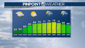
Scattered showers and storms will continue to move across the Front Range this afternoon and evening. Lightning will be the main threat over Metro Denver. There is a potential for stronger storms on the northeast plains with up to quarter size hail and up to 60mph wind gusts. Storms will clear out late this evening leaving cloudy skies behind to start off Monday.
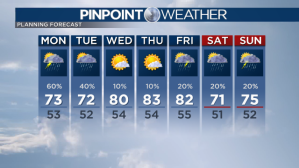
Monday will be cooler on the Front Range with high temperatures reaching the low 70s in Denver. Sunshine will break out by midday with storm chances in the afternoon and evening. Storms might slow down the Monday evening commute for some.
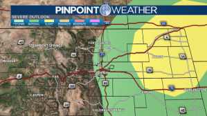
There is a risk of severe weather on the Front Range and eastern plains tomorrow. The areas in yellow have the highest risk to see hail and gusty winds but a few isolated severe storms can’t be ruled out closer to the I-25 corridor.
Our afternoon stormy weather pattern will continue for Tuesday.
Drier weather will move in by Wednesday and Thursday with high temperatures returning to the 80s.
Check interactive radar and zoom in to where you are. Plus, check the radar anytime with the Pinpoint Weather App for iPhone and Android.

Pinpoint Weather has been independently certified as Colorado’s Most Accurate Forecast by WeatheRate.
We’re tracking weather today on FOX31 Denver and Channel 2 News – and when conditions are bad we send out the Weather Beast.


