Around the world, organizations use GIS to visualize the built environment, make smarter plans, engage stakeholders, and foster vibrant communities. Next month at the 2019 Esri User Conference in San Diego (July 8th – 12th), connect with Smart City and 3D GIS experts to learn about the latest GIS software and experience how Esri’s technology has transformed the way information can be managed, utilized, and integrated with your enterprise GIS. To help you find your way to the Smart Cities sessions and events, we have prepared a more focused agenda, which you can download here. We’ve also highlighted several key activities and events in this blog post – read on for more information.
Expo Hall – 3D / Smart Cities Showcase
The User Conference Expo is the place to explore, collaborate, learn, and find inspiration. It is an important spot to browse during your conference experience! We encourage you to visit the 3D / Smart Cities Showcase in the Expo Hall to see GIS solutions for all aspects of your organization and community. The 2019 showcase will focus on 3D Solutions, as well as new products such as ArcGIS Urban and ArcGIS Indoors.
Tuesday, July 9th 9:00 AM–6:00 PM
Wednesday, July 10th 9:00 AM–6:00 PM
Thursday, July 11th 9:00 AM–4:00 PM
Feel free to stop by the showcase at your convenience. If you would prefer, however, you can schedule a meeting ahead of time by emailing mschueren@esri.com.
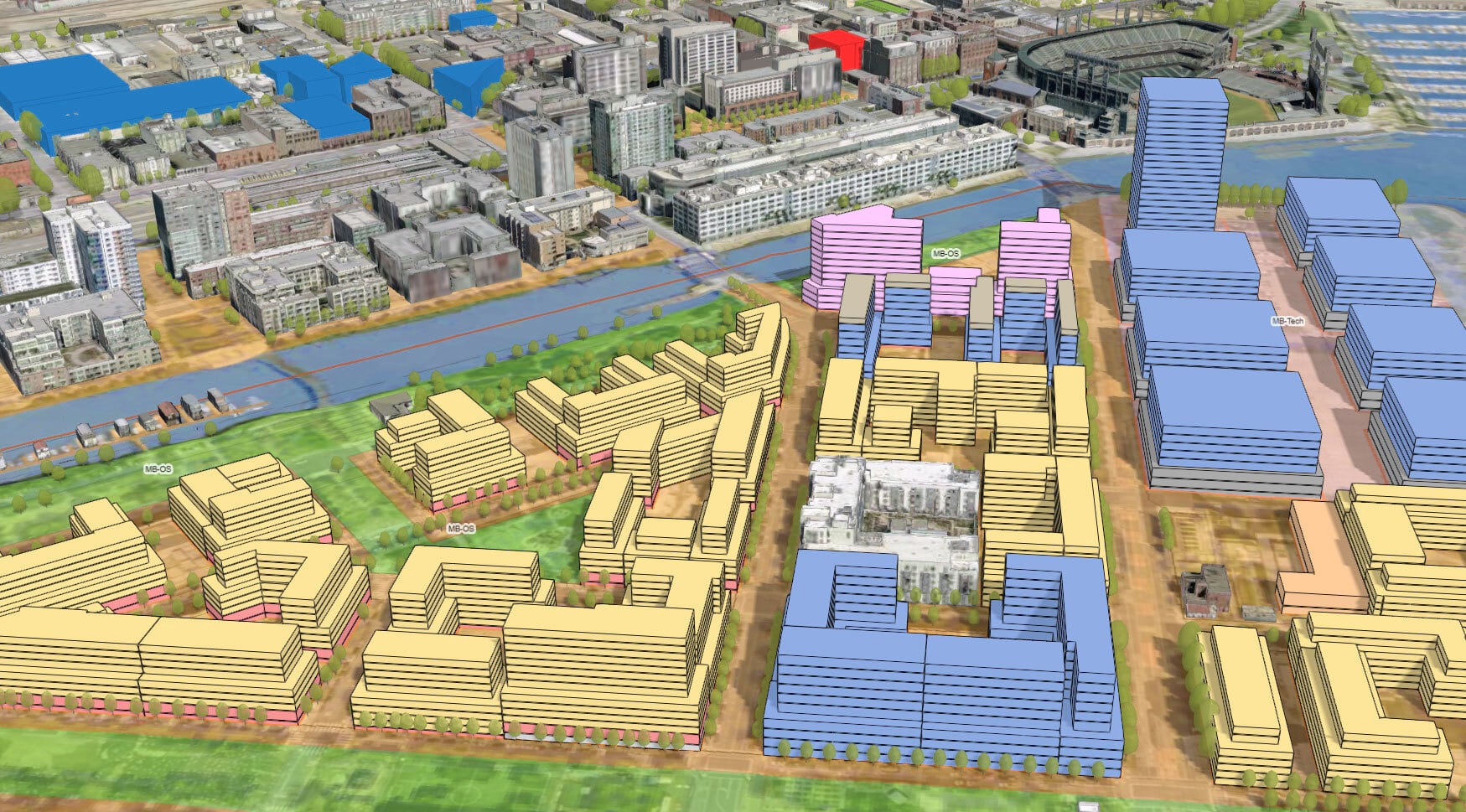
ArcGIS Urban
This year at the User Conference, we’re excited about the release of ArcGIS Urban. This geo-enabled system is much more than a product to help you design, manage and measure the impact of your plans – it’s a new way of collaborating across departments and agencies to make the right decisions for the community. There will be a number of ArcGIS Urban events and activities at the UC this year, with many opportunities to learn how you can take advantage of this new tool to advance your smart organization. To help you prioritize – we’ve pulled out a few must-attend events below.
Getting Started with ArcGIS Urban | Pre-Conf Seminar
July 6th, 2019 | San Diego Convention Center (SDCC)
The weekend before the conference kicks off, you can attend a pre-conference seminar focused on ArcGIS Urban. This workshop will provide an overview of the new product, showing how you can use web-based tools for orchestrating urban development Plans and Projects. The workshop will also cover how to use ArcGIS Urban’s native 3D capabilities to understand the local real estate development “pipeline” of active projects and zoning-based development potential for any parcel within a planning study area. Ultimately – you’ll be able to explore the use of Urban’s geodesign tools to create and evaluate multiple scenarios, using metrics and performance indicators as design feedback. A quick note – additional registration and fees are required for this seminar. Please contact 1-888-377-4576 between 9:00 a.m. – 4:00 p.m. (PST) to add a pre-conference seminar to your registration. You can find more information on this seminar, as well as other seminars here.
ArcGIS Urban Special Interest Group Meeting
Tuesday, July 9th, 5:30 pm – 7:00 pm | SDCC – Center Terrace (Upper Level)
Attend the 2nd annual ArcGIS Urban Special Interest Group meeting at this year’s Esri UC. This SIG is an excellent place to join your Urban Planning peers to network and exchange ideas, as well as hear the latest road map from our team of specialists on this exciting new initiative. Registration details: https://go.esri.com/urbansig
ArcGIS Urban Readiness Check
Expo Hall Hours | Urban Lab Kiosk at the ArcGIS Urban Showcase
Are you excited to learn more about ArcGIS Urban? Are you wondering what data and software you need? Do you have questions about how to get started? Sign up today for an ‘Urban-Ready’ Check and discuss all your Urban questions one-on-one with an Esri expert. An ‘Urban-Ready’ check is a free, 30-minute one-on-one consulting service with an Esri expert who will provide you with an overview of ArcGIS Urban’s exciting capabilities and discuss how it could be applied to meet your specific community’s needs. Want to dive deeper? Take full advantage of this opportunity and bring a sample of your parcel and zoning data to review with the Esri expert and get custom recommendations for how to get started. Register by email: jmcfarlane@esri.com.
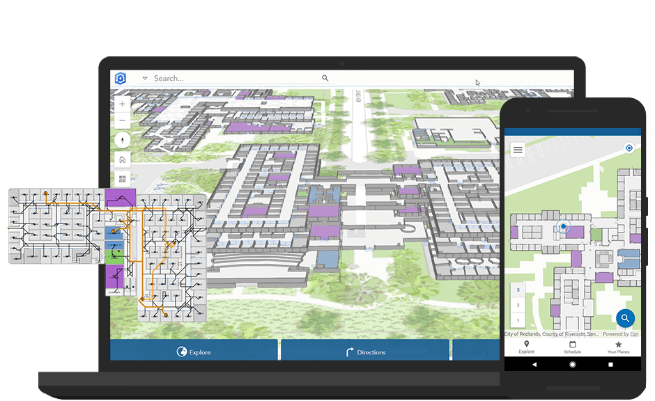
ArcGIS Indoors
Earlier this year, Esri released ArcGIS Indoors – a complete system for indoor mapping used to create a connected workplace. It provides a common operating picture for executives, workplace services personnel, and other employees and visitors to understand, manage, and use their workplace environment. At the UC, learn more about ArcGIS Indoors and find out how a transparent working environment can be created to help improve efficiencies through increased spatial awareness, building intelligence and resource planning, indoor positioning and navigation, and analytical data.
Technical Workshops & Indoors-Focused Sessions
If you want to get first-hand insights from experts into the ArcGIS Indoors web and mobile application, we recommend attending one or many of the Indoors-focused sessions throughout the conference. From introductions to deep dives on the product, there is something for everyone during the week. We’ve pulled out a few sessions that might be of interest below:
| Tuesday, July 9 | ||
| 10:00AM | ArcGIS Indoors: An Introduction | SDCC, Room 14 A |
| 11:30AM | Esri Solutions for Smart Campuses | SDCC, Room 24 A |
| Wednesday, July 10 | ||
| 4:00PM | ArcGIS Indoors: An Introduction | SDCC, Room 14 A |
| Thursday, July 11 | ||
| 10:00AM | Configuring ArcGIS Indoors to Optimize Your Workplace | SDCC, Room 14 B |
| 1:00PM | ArcGIS Indoors: Integration with IoT | SDCC, Room 14 A |
| 2:30PM | ArcGIS Indoors: Turn Your CAD and BIM Data Into A Workplace Map | SDCC, Room 10 |
Esri Solutions for Smart Campuses | Special Interest Group
July 9th, 2019 | SDCC, Room 24 A
We will also host an Indoors Special Interest Group (SIG) focused on Smart Campuses during the conference. Educational institutions are faced with many challenges that affect the quality of life for faculty, students, and visitors. These challenges have an impact on campus operational maintenance, safety and security, and sustainability. Esri not only provides applications to support these challenges, our smart campus solutions connect to your existing systems of record, providing comprehensive management over facility + indoor assets, utilities, planning, and security efforts. Ultimately, a smart campus GIS enhances efficiency and communication across your institution. Please join us to learn and discuss how ArcGIS can benefit your campus and to share your experiences in bringing GIS into your work.
3D GIS & Smart Cities
The GIS of the future is 3D, a model of the real-world that provides an engaging and intuitive interface for visualization, analysis, monitoring, and sharing. This technology is an integral part of your organization’s transformation into a smart organization – leveraging the latest technology to drive innovation & move forward. And recent technology advances in data collection—such as “reality capture” from drones or airplanes, building information models (BIM), commercial “street view” equipment, 3D photogrammetry, and Internet of Things (IoT) sensors—are creating massive amounts of rich 3D data that can be transformed into useful, actionable information. Attend one of the many sessions leveraging cutting edge technology in the 3D and Smart Cities space.
Also, be sure to check out theater sessions to dive deep into 3D and see how it’s all done. Esri staff will demonstrate the latest in 3D technology, from CityEngine to Web Scenes, and provide the audience with great tips & tricks to implement into current GIS workflows. The sessions highlighted below run the gamut of all things 3D and Smart Cities.
| Tuesday, July 9 | ||
| 8:30am | ArcGIS Earth: An Introduction | SDCC, Room 14 A |
| 8:30am | ArcGIS Pro: 3D Tips and Tricks | SDCC, Ballroom 06 D |
| 10:00am | 3D Cartographic Techniques: An Introduction | SDCC, Ballroom 06 E |
| 2:30pm | BIM and GIS: An Introduction | SDCC, Room 05 A |
| Wednesday, July 10 | ||
| 8:30am | 3D Analysis in ArcGIS Pro | SDCC, Room 16 B |
| 10:00am | 3D Content Sharing to the Web | SDCC, Room 16 B |
| 1:00pm | 3D Feature and Sub-Surface Analysis | SDCC, Room 16 B |
| 2:30pm | 3D Mesh and Lidar Point Clouds | SDCC, Room 16 B |
| 4:00pm | 3D Cartographic Techniques: An Introduction | SDCC, Ballroom 06 A |
| Thursday, July 11 | ||
| 8:30am | 3D Analysis in ArcGIS Pro | SDCC, Room 14 A |
| 10:00am | 3D Content Sharing to the Web | SDCC, Room 14 A |
| 1:00pm | 3D Feature and Sub-Surface Analysis | SDCC, Room 14 A |
| 1:00pm | 3D Mesh and Lidar Point Clouds | SDCC, Room 14 B |
| 2:30pm | 3D Cartographic Techniques: An Introduction | SDCC, Room 10 |
Every community aspires to be a Smart Community – driving insight and innovation by taking advantage of location data and technology. And today – harnessing the power of GIS to enable your smart organization has never been easier. We hope to see you at one or many of the events listed above!

Commenting is not enabled for this article.