New round of heavy snow, travel disruptions to target midwestern US early this week
A large storm will threaten to disrupt travel and daily routines as it unleashes heavy snow and gusty winds across the midwestern United States through Tuesday.
This storm follows a snow event to end this past weekend, which unleashed as much 5-7 inches of snow in portions of Minnesota and Wisconsin.
An expansive winter storm will take shape across the northern Plains into Tuesday, according to AccuWeather Storm Warning Meteorologist Billy Clark.
Snow is expected to fall and create slippery conditions from Bismarck, North Dakota to Sioux Falls, South Dakota; Minneapolis; Des Moines and Cedar Rapids, Iowa; Madison, Milwaukee and Green Bay, Wisconsin; and Traverse City and Marquette, Michigan.

The highest snowfall totals and worst travel conditions are expected to focus on the upper Mississippi Valley from late Monday to Tuesday night.
The heaviest snow will fall across Iowa and into southern and eastern Minnesota and central Wisconsin, according to Clark.
Heavy snow will spread into northern Wisconsin and the Upper Peninsula of Michigan Tuesday into Tuesday night.
In these areas, there can be 6-12 inches of snow with an AccuWeather Local StormMax™ of 18 inches.
"Disruptions to logistical operations are expected due to heavy snowfall causing hazardous travel conditions," Clark said.
School closures are likely.
Stretches of interstates 29, 35, 80, 90 and 94 are expected to be difficult and dangerous to travel on during the height of the storm.
In addition to snow-packed, slippery roadways, blowing and drifting snow can create whiteout conditions as winds strengthen around the storm.
"There may be several hours of wintry precipitation and wintry travel conditions from I-80 to Chicago and Detroit," AccuWeather Senior Meteorologist Alex Sosnowski said.
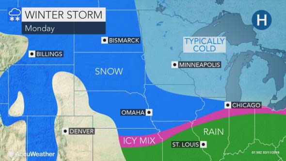
Snow is forecast to transition to an icy mix in this corridor from late Monday through Monday night.
Once snow or ice changes to plain rain, most of the time the air dries out as the storm moves away. However, there may be a burst of snow several hours after the change to rain has taken place in part of the Midwest on Tuesday.
"This quick change to accumulating snow can occur around St. Louis during Tuesday morning, Indianapolis during Tuesday midday and Detroit in time for the Tuesday evening rush hour," Sosnowski said.
Thunder and lightning may accompany the burst of snow in some areas.
Download the free AccuWeather app to see exactly what to expect in your area.
The storm's broad nature will bring snow, ice and slippery travel to much of the Northeast from Monday night to Tuesday. In the mid-Atlantic and central Appalachians this storm may blend in from leftover snow and ice from a weak storm that affected the region from Sunday night to Monday.
Meanwhile, enough rain may fall to aggravate the flooding situation from Arkansas, Tennessee and Kentucky, to the southern Indiana and much of Ohio.
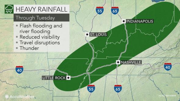
There can be a rapid freeze-up in the lower Ohio Valley later Tuesday as temperatures plunge behind the rain, causing any lingering wet areas to turn to ice.
The Central states will then have to brace for yet another winter storm at late week.