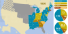
U.S. Voting Blocs: Groups of States That Have Been Won by the Same Candidate in Every Presidential Election Since 1960.
[[MORE]]by delugetheory:
If anyone is wondering why I chose 1960 as the cut-off date, it’s for two reasons. 1960 is the first...

U.S. Voting Blocs: Groups of States That Have Been Won by the Same Candidate in Every Presidential Election Since 1960.

by delugetheory:

If anyone is wondering why I chose 1960 as the cut-off date, it’s for two reasons. 1960 is the first election year that the U.S. had all 50 of its present states. It’s also right about the time of the beginning of the Republican Southern Strategy that saw the major realignment of the Republican and Democratic parties in response to the Civil Rights movement, which gave us the parties as they exist today.

I didn’t include them in the map, but I did come up with some names for the blocs as I was creating the map:

  • The Dixie Alliance (AL, MS)
  • The Pioneer Alliance (AK, ID, KS, ND, NE, OK, SD, UT, WY)
  • The Appalachian Alliance (KY, TN)
  • The Mountain Republic Alliance (CA, VT)
  • The Midland Alliance (IL, NJ)
  • The Island Alliance (HI, RI)

Related Posts

nyplmaps:
“Mapping the vote via cartogram, in which it is shown that in 1944 New York and Jersey alone had a greater portion of the total vote than nearly all of the United States west of the Mississippi. 🇺🇸🇺🇸🇺🇸
Map: Roosevelt and Dewey States -...1836 US presidential election.
All the United States presidential elections, from 1789 through 2012: http://gdanielsphoto.blogspot.com/p/vectoring-election-maps.htmlWhat if Canada Could Vote in United States elections?spifczyk:
“ These two maps show the exact same thing - results of the 2016 presidential election in the lower United States. The upper map seems dire to people like me, who believe Donald Trump is a bad person in general and a horrible person for...Popular vote at the 1880 US elections.
More old maps of the US >>postgraphics:
“ These state-level elections could change the balance of power in Congress for a decade State legislators and governors often control the redrawing of U.S. House maps.
See how redistricting works in your state
”jedavu:
“The Minimal Maps Project
Based in London, designer Michael Pecirno is the author of the ongoing project “Minimal Maps”. He wanted to represent datas with a new imagery from the map of The United States and highlighting visually the water...A new and correct map of the United States of North America is the first map of the United States drawn and printed in the US by an American; it was printed in Connecticut by Abel Buell in March 1784, six months after the Treaty of Paris.
More old...People were asked to divide the United States into exactly five general regions
[[MORE]] atrubetskoy:
“ This map shows how Americans see the United States divided into five regions. It shows the average of a total 612 responses to the question,
“If...United States presidential election, 1924.
[[MORE]]by ProudThatcherite:
Source: https://en.wikipedia.org/wiki/United_States_presidential_election,_1924
Republican candidate: Calvin Coolidge (Massachusetts)
Democratic candidate: John W. Davis (West...
Comments powered by Disqus
  1. srslynotveryamused reblogged this from mapsontheweb
  2. itsbeartime reblogged this from mapsontheweb
  3. yourgodsarentreal reblogged this from mapsontheweb
  4. darkcloudsbrightskies reblogged this from mapsontheweb
  5. tevis-larsen reblogged this from mapsontheweb
  6. spatialisspecial reblogged this from mapsontheweb
  7. homosexuallifestylecoach said: Mega FAIL
  8. liberal-scum reblogged this from mapsontheweb
  9. lordgibbon reblogged this from mapsontheweb
  10. acrosstherachelverse reblogged this from mapsontheweb
  11. itendswithz reblogged this from mikerickson
  12. hazelsmazecave said: @vmcla @prussianmemes​ It took me a while but I get it now, it’s just states with the same voting history.
  13. intothewildgreenwhatever reblogged this from mapsontheweb
  14. mapsontheweb posted this