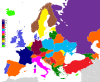
![Percentage of land covered by a country in the quadrilateral made by its extreme latitudes and longitudes.
[[MORE]] kei-kurono2:
Different colour...](https://64.media.tumblr.com/bd9081afadc14f77b4aa9608cd3f8012/tumblr_ozddp7aeKi1rasnq9o1_1280.jpg)
Percentage of land covered by a country in the quadrilateral made by its extreme latitudes and longitudes.
Different colour scheme.
https://i.imgur.com/NCENpVz.jpg
Sources:
https://en.wikipedia.org/wiki/List_of_countries_by_easternmost_point
https://en.wikipedia.org/wiki/List_of_countries_by_northernmost_point
https://en.wikipedia.org/wiki/List_of_countries_by_southernmost_point
https://en.wikipedia.org/wiki/List_of_countries_by_westernmost_point
Method 1 was to calculate area of polygon
http://stackoverflow.com/questions/1340223/calculating-area-enclosed-by-arbitrary-polygon-on-earths-surface
Only mainland is considered.
Related Posts
![Countries that are currently supported with Google Maps Navigation
[[MORE]]
binarypower:
New counties added:
• Angola
• Bahamas
• Bolivia
• Botswana
• Fiji
• Guyana
• Honduras
• Jamaica
• Madagascar
• Malawi
• Mali
• Malta
• Mauritius
• Mozambique
•...](https://64.media.tumblr.com/ea2469e9ebf8ce8be3fe67bb6b24087e/tumblr_nc5kae8OHN1rasnq9o1_100.png)


![Diplomatic Missions: Sending countries and receiving countries
[[MORE]]
daysleeperrr:
I made this by scraping these 208 wikipedia pages. It includes embassies, consulates and interest sections, as long as they are based in the receiving country (So a...](https://64.media.tumblr.com/a4f5b92c28a05b3f4ff73ee24fb7de9b/tumblr_n9c0qiVevt1rasnq9o1_100.png)


