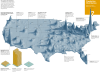
![The Hole, an area of the northern plains with the population density of Alaska or Mongolia.
[[MORE]] Alfalfa_Sproutz:
“The Hole is home to around 35600 people across 22000 square miles (about the size of Tasmania or Croatia). For comparison, Wyoming...](https://64.media.tumblr.com/7f6c7291a4833a46ca1608650b18a54b/tumblr_oex4cuLYCQ1rasnq9o1_1280.png)
The Hole, an area of the northern plains with the population density of Alaska or Mongolia.
The Hole is home to around 35600 people across 22000 square miles (about the size of Tasmania or Croatia). For comparison, Wyoming as a whole has 6 people per square mile. The largest city is Belle Fourche at around 5600 people, and it is actually by far the largest city (the next biggest, Baker Montana, is less than half that size).
The Hole is probably the largest contiguous block of land in the lower 50 states (that forms a convex shape rather than blobbing around cities and towns) to reach such a low population density. Crucially, the entire area lies beyond the Frontier Line. In the 1890 census, the frontier was declared closed because there was no longer a line beyond which the population density dropped below 2 people per square mile. While that is still true on a state-wide scale, the emptying out of the prairie has opened up large swathes of territory like The Hole, in which conditions are what the 1890 census would have considered an untamed frontier land.
Related Posts
![Countries that India would take up if it was a dense as the United States
[[MORE]]
Vitaemium:
Source:
Population of India: http://data.worldbank.org/indicator/SP.POP.TOTL?order=wbapi_data_value_2013+wbapi_data_value&sort=desc
Population Density of...](https://64.media.tumblr.com/0c5433e709ad8d2080960f7e115221b7/tumblr_nhcdaqOvIV1rasnq9o1_100.png)
![Population Density of Contiguous United States by Census Block.
[[MORE]]Data source: https://www.census.gov/geo/maps-data/data/tiger-data.html, QGIS
This is literally the lowest geographical area the United States has. There are around 8.3 million...](https://64.media.tumblr.com/27730c938ca01780f146568a533be80a/tumblr_nmprlroOWu1rasnq9o1_100.png)
![Population density of Africa with US equivalents.
[[MORE]]by trampolinebears:
This map shows the population density of Africa by labelling each country for the US state with the nearest density. Previous maps in the series:
• Europe as US
• US as...](https://64.media.tumblr.com/c9961d19171c0f54efc581a4c4d80529/tumblr_oxq4c9u5wn1rasnq9o1_100.jpg)