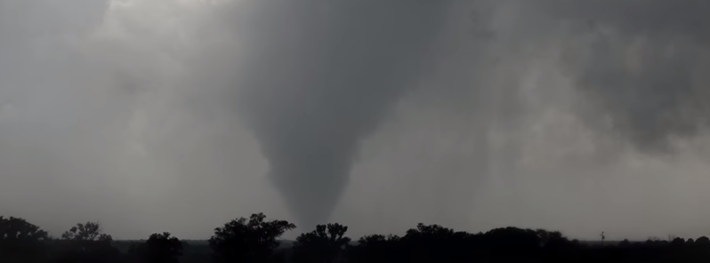
US Plains, Midwest and South face severe weather until the end of the week

A widespread outbreak of severe weather has been taking place across portions of the US Plains, Midwest and South since May 21, 2016. Intense thunderstorms accompanied with hail, strong winds and tornadoes are set to continue throughout the coming week. Isolated events of heavy rainfall could trigger flash flooding across the affected areas.
Multiple tornadoes were reported in Texas, Kansas and South Dakota on May 22. Tornado touchdowns were observed near Howardwick and near Big Springs in Texas while another large tornado near Waka tore down 0.4 km (0.25 miles) long row of power lines. A 0.8 km (0.5 miles) wide tornado was spotted near Lydia, Kansas. Luckily, no significant damage occurred despite the outbursts.

Video credit: Joey Krastel


Video credit: Forever Chasing


Video credit: Max Olson Chasing
On the evening of May 22 (local time) intense hailstorm battered regions near Post and Elbow in Texas. Hailstones about 6.35 cm (2.5 inches) in diameter (the size of a tennis ball) reportedly broke car windows near Post while the hailstones the size of a teacup (7.62 cm or 3 inches) were observed near Elbow. Intense thunderstorms caused the residents near Mullen, Nebraska to lose power.
The strong thunderstorms are caused by the eastward moving ripples of energy, ejected from a southward dip in the jet stream spreading over the West. Energy ripples in combination with abundant moisture coming from the Gulf of Mexico are feeding the thunderstorms in question.
According to the NWS, severe thunderstorms will affect portions of the Plains throughout this week, during afternoons and evenings (local time). Storms will likely be accompanied with large hail, damaging winds, and a few tornadoes while local heavy rainfall could induce flash flooding, especially across parts of the Great Plains and Mississippi Valley.


Image credit: DOC/NOAA/NWS/NCEP/Weather Prediction Center


Image credit: DOC/NOAA/NWS/NCEP/Weather Prediction Center


Image credit: DOC/NOAA/NWS/NCEP/Weather Prediction Center
On May 23, scattered intense thunderstorms accompanied with strong winds, large hail and possibly a couple of tornadoes will affect parts of Minnesota, western Wisconsin, Oklahoma and Texas. The largest tornado risk zone will spread from western Kansas to western Oklahoma and Texas.
Regions from Iowa and Nebraska, parts of Kansas, Missouri, Oklahoma and north Texas can expect severe scattered thunderstorms, large hail, strong winds and tornadoes on May 24 while the eastern Plains, parts of Missouri, Illinois, and Arkansas can expect severe weather conditions on May 25.
The Plains and South region could see severe weather conditions to continue on May 26.
Featured image: Tornado near Howardwick, Texas, May 22, 2016. Image credit: Max Olson Chasing

Commenting rules and guidelines
We value the thoughts and opinions of our readers and welcome healthy discussions on our website. In order to maintain a respectful and positive community, we ask that all commenters follow these rules.