The largest earthquake recorded by instruments – M9.5, Chile (1960)
The largest earthquake ever recorded by instruments hit southern Chile at 19:11 UTC on May 22, 1960. It was a 9.5 magnitude earthquake with a focal depth of 33 km (20.5 miles), preceded by 4 aftershocks bigger than M7.0, including M7.9 on May 21 that caused severe damage in the Conception area.
 The rupture zone of this earthquake, known as the 1960 Valdivia earthquake or Great Chilean earthquake, is estimated to be about 1 000 km long (621 miles), from Lebu to Puerto Aisen.
Many aftershocks occurred, with 5 of M7.0 or greater through November 1.
The Pacific seafloor (Nazca Plate) slid 15 meters (50 feet) beneath the continent of South America.
"Like a spring, the lower slopes of the South American continent offshore snapped upwards as much as 6 m (20 feet) while land along the Chile coast dropped about 3 m. This change in the shape of the ocean bottom changed the shape of the sea surface. Since the sea surface likes to be flat, the pile of excess water at the surface collapsed to create a series of waves – the tsunami," Dr. Gerard Fryer, Hawaii Institute of Geophysics & Planetology, explains.

Video credit: CBS
Severe damage from shaking occurred in the Valdivia – Puerto Montt area. Most of the casualties and much of the damage was because of large tsunamis which caused damage along the coast of Chile from Lebu to Puerto Aisen and in many areas of the Pacific Ocean.

A Valdivia street after the earthquake – damage to good quality, wood-frame houses. Photo credit: Pierre St. Amand – NGDC Natural Hazards Slides with Captions Header.
Puerto Saavedra was completely destroyed by waves which reached heights of 11.5 m (38 feet) and carried remains of houses inland as much as 3 km (2 miles). Wave heights of 8 m (26 feet) caused much damage at Corral.


According to the USGS, approximately 1 655 people were killed by this earthquake, 3 000 were injured and 2 000 000 were left homeless.
Tsunamis caused 61 deaths and severe damage in Hawaii, mostly at Hilo, where the runup height reached 10.6 m (35 feet). Tsunami arrived at Hilo about 15 hours after it originated, 10 600 km (6 600 miles) away.
It changed into a bore as it passed the harbor entrance and advanced on to the bay front. The business district along Kamehameha Avenue and the adjoining low-lying residential areas of Waiakea and Shimmache were destroyed. Damage to property included 229 dwellings and 308 business and public buildings. (NGDC) Between the Wailoa and Wailuku Rivers, the water washed inland as far as the 6 m (20 feet) contour above sea level.
Waves as high as 5.5 m (18 feet) struck northern Honshu, Japan about 1 day after the quake, where it destroyed more than 1 600 homes and left 185 people dead or missing.
Another 32 people were dead or missing in the Philippines. Damage also occurred on Easter Island, in the Samoa Islands and in California.
A seiche of more than 1 was observed on Panguipulli Lake, southern Chile following the earthquake. Another seiche occured on May 22 in Nahuel Huapi Lake, on the Argentinean side of the Andes, more than 200 km (124 miles) away from Valdivia. The wave killed two people and destroyed a pier in San Carlos de Bariloche city.
One to 1.5 m (3 – 5 feet) of subsidence occurred along the Chilean coast from the south end of the Arauco Peninsula to Quellon on Chiloe Island. As much of 3 m (10 feet) of uplift occurred on Isla Guafo.
Many landslides occurred in the Chilean Lake District from Lago Villarica to Lago Todos los Santos.

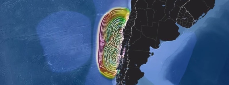
This side-by-side comparison of three tsunamis generated within the same region highlights two important characteristics of tsunami behavior.
First, the height of the tsunami waves (as shown by color) is strongly dependent on the size of the earthquake, namely its moment magnitude (Mw). The 9.5 Mw earthquake of 1960 released approximately 11 times more energy than the 8.8 Mw earthquake of 2010 and approximately 89 times more energy than the 8.2 Mw earthquake of 2014. Likewise, the tsunami wave heights were far larger in 1960 than they were in 2010, and larger in 2010 than they were in 2014.
Second, the speed of a tsunami does not depend on the size of the earthquake. All three tsunamis move at about the same speed regardless of their size because their waves are so large that they interact with the sea floor. Therefore, both the ocean depth and its local variations control the speed of the tsunami waves.
Video credit: PTWC.
On May 24, Puyehue – Cordon Caulle volcano, located 300 km SE of the epicenter, entered a new eruptive phase which lasted for several weeks (VEI 3). The eruption fed a 5.5 km long and N135° trending fissure where 21 individual vents have been found. These vents produced an output of about 0.25 km3 DRE both in form of lava flows and tephra.
The eruption lasted until the end of June.

Ash-laden eruption plumes rise above a fissure vent at Cordón Caulle volcano on May 24, 1960. Photo by Oscar González-Ferrán, 1960 (University of Chile).

Video credit: Alltime10s
Featured image credit: PTWC
Commenting rules and guidelines
We value the thoughts and opinions of our readers and welcome healthy discussions on our website. In order to maintain a respectful and positive community, we ask that all commenters follow these rules:
We reserve the right to remove any comments that violate these rules. By commenting on our website, you agree to abide by these guidelines. Thank you for helping to create a positive and welcoming environment for all.